
Determine the contour interval used on this map
Contour interval:_________________ feet.
![]()
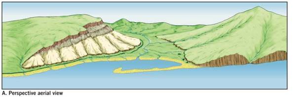
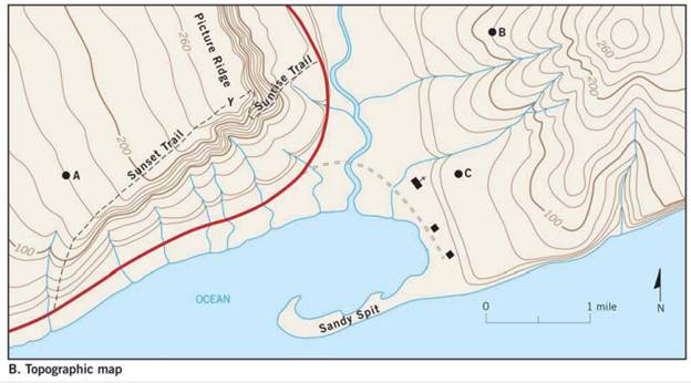
The counter interval used on the given topographic map of a hypothetical area.
Introduction:
Topographic maps represent large scale structures of the Earth surface such as hills, streams, and valley. The contour interval is defined as the difference in the vertical elevation between the adjacent contour lines.
Explanation of Solution
Contour interval is calculated by the given formula:
The difference in elevation from the given map is calculated as:
Number of contour lines are 5
Therefore, by substituting the following values in equation (I),
Hence, the counter interval used on the given map is 20 feet.
Want to see more full solutions like this?
Chapter 7 Solutions
APPLICATIONS+INVESTIGATIONS IN EARTH
Additional Business Textbook Solutions
Exercises for Weather & Climate (9th Edition)
Applications and Investigations in Earth Science (8th Edition)
Introduction to Electrodynamics
Chemistry & Chemical Reactivity
Human Physiology: An Integrated Approach (7th Edition)
Brock Biology of Microorganisms (15th Edition)

 Essentials Of InvestmentsFinanceISBN:9781260013924Author:Bodie, Zvi, Kane, Alex, MARCUS, Alan J.Publisher:Mcgraw-hill Education,

 Foundations Of FinanceFinanceISBN:9780134897264Author:KEOWN, Arthur J., Martin, John D., PETTY, J. WilliamPublisher:Pearson,
 Fundamentals of Financial Management (MindTap Cou...FinanceISBN:9781337395250Author:Eugene F. Brigham, Joel F. HoustonPublisher:Cengage Learning
 Corporate Finance (The Mcgraw-hill/Irwin Series i...FinanceISBN:9780077861759Author:Stephen A. Ross Franco Modigliani Professor of Financial Economics Professor, Randolph W Westerfield Robert R. Dockson Deans Chair in Bus. Admin., Jeffrey Jaffe, Bradford D Jordan ProfessorPublisher:McGraw-Hill Education