
On Figure 23.12, prepare a diagram illustrating Earth’s grid system, include and label the equator and prime meridian. Explain the system used for locating points on the surface of Earth. Refer to Figure 23.1, page 370, if necessary. ______________
To draw:
The Earth’s grid system, including equator and prime meridian and also description of the system used to locate points on Earth’s surface.
Introduction:
The maps and globes display the system of east-west, and north-south lines, which is described as the Earth’s grid.
Explanation of Solution
Pictorial representation: Figure 1 represents the Earth’s grid system.
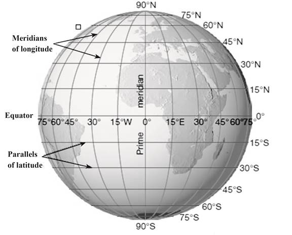
Fig. 1: Earth’s grid system
The north-south lines in figure 1 represent parallels of latitude, and the east-west lines represent meridians of longitude. The Earth’s grid system generates the basis for locating the points on the surface of Earth. The position of a specific point can be determined by the intersection of two lines. At prime meridian, the longitude is described as 0°. The location of a point is measured in degrees west and east of prime meridian from 0° to 180°.
Want to see more full solutions like this?
Chapter 23 Solutions
APPLICATIONS+INVESTIGATIONS IN EARTH
Additional Business Textbook Solutions
Applications and Investigations in Earth Science (8th Edition)
Exercises for Weather & Climate (9th Edition)
Organic Chemistry (8th Edition)
Microbiology: An Introduction (13th Edition)
Human Anatomy & Physiology (Marieb, Human Anatomy & Physiology) Standalone Book
Microbiology: An Introduction

- I need to calculate the horizontal and vertical analysis for the following image that is attached.arrow_forwardPlease help wiith the steps on how to calculatearrow_forwardOn the graph presented, match each element to its appropriate description. H B E (A Element Description Point A Area G Area C Line H Line I Area B Area F Axis E Axis Darrow_forward
 Individual Income TaxesAccountingISBN:9780357109731Author:HoffmanPublisher:CENGAGE LEARNING - CONSIGNMENT